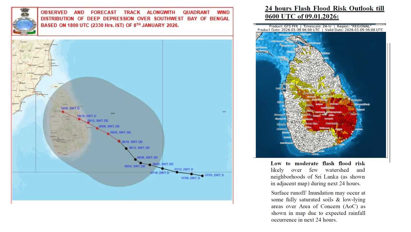
The forecasted path of a depression expected to impact Sri Lanka has been adjusted northwards towards Trincomalee, with heavy rainfall anticipated for the North-central, Eastern, and Uva provinces, as well as the Matale district today. Rainfall of approximately 150 millimeters is projected for Saturday. Meteorologists have indicated that the deep depression may strike further north than initially predicted by weather models.
“The deep depression in the Bay of Bengal, located southeast of Sri Lanka, is very likely to intensify and move west-northwestwards towards the Sri Lankan coast between Pottuvil and Trincomalee by the evening of January 9, 2026,” stated Sri Lanka’s meteorological office. “The latest forecast track has significantly altered due to the system’s uncertainties.”
The Regional Specialized Meteorological Center (RSMC) in New Delhi, utilizing data available at 11:30 PM on Thursday, reported that the ECMWF model suggests a slight increase in northward movement and a shift in the landfall point to between Trincomalee and Pottuvil, when the system was approximately 200 kilometers off Pottuvil.
“There is considerable uncertainty in various runs of the ECMWF models,” noted RSMC meteorologist Shashi Kant in an advisory. “Models such as the GFS group and NCUM are not accurately capturing the system’s intensity. The current forecast is based on consensus derived from persistence and ECMWF model guidance.” The RSMC assessed the confidence in the forecast track as ‘moderate’.
The Sri Lankan meteorological office advises coastal residents to relocate inland. The following actions are suggested for the land area:
- Residents of coastal huts are advised to move to safer locations. Others in affected areas should remain indoors.
- Individuals living in hilly regions, particularly those prone to landslides, and low-lying river basin areas, should remain vigilant.
- Drivers and road users in hilly areas are advised to exercise caution.
- Be cautious of fallen trees and power lines.
- Avoid using wired telephones and connected electrical appliances during thunderstorms.
- The general public is urged to stay alert to the impending extreme weather situation.
- For emergency assistance, contact local disaster management authorities.
- Stay updated with future advisories issued by the Department of Meteorology.
For the sea area, the following actions are advised:
- Naval and fishing communities are warned against venturing into the deep and shallow sea areas around the island until further notice.
- They are also advised to avoid the sea areas bounded by coordinates (03N – 13N) and (76E – 86E) until further notice.
- Those already in the mentioned sea areas should return to the coast or move to safer locations immediately.