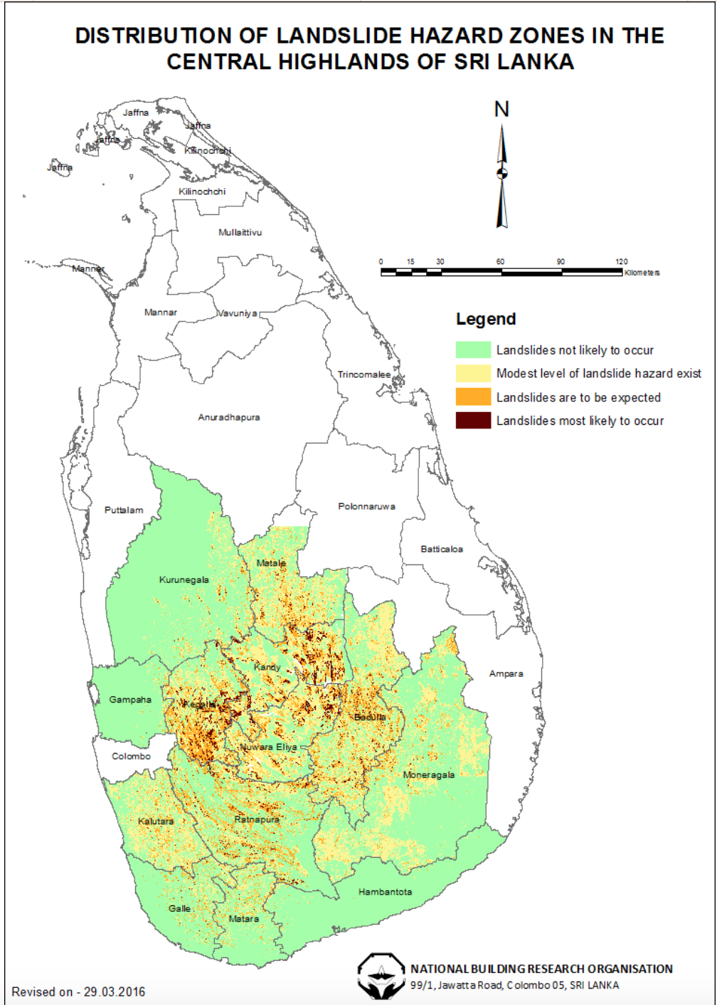
The Landslide Research and Risk Management Division (LRRMD) of the National Building Research Organisation (NBRO) has intensified its landslide hazard zonation mapping initiative, now covering 13 districts identified as highly vulnerable to slope failures. The program initially focused on 10 landslide-prone districts—Kalutara, Galle, Hambantota, Nuwara Eliya, Matale, Kandy, Kegalle, Ratnapura, Matara and Badulla—but has since expanded to include Monaragala, Gampaha and Kurunegala, NBRO announced.
The mapping identifies the severity of landslide hazards and is designed to serve as a decision-making tool for planners and developers working in Sri Lanka’s central highlands. NBRO stated that the maps are also valuable for identifying elements at risk, relocation and rehabilitation planning, distributing disaster relief funds, and guiding insurance assessments.
According to the LRRMD, mapping is carried out at two scales—1:50,000 for district-level coverage and 1:10,000 for high-risk zones with significant development potential. Comprehensive 1:50,000 maps are now available for all 13 landslide-prone districts and can be accessed by government agencies, developers, researchers, and the general public.
The more detailed 1:10,000 hazard maps are developed using extensive field studies and evaluation of six major causative factors. These maps currently cover thousands of square kilometres across several districts, including 1,280 sq. km in Ratnapura, 1,280 sq. km in Badulla, 1,120 sq. km in Kegalle, 760 sq. km in Nuwara Eliya, 640 sq. km in Kalutara, and significant portions of Kandy, Matara, Galle, Hambantota and Matale. NBRO also confirmed that mapping for an additional 320 sq. km in Kurunegala and 200 sq. km in Matale is underway, and expected to be completed by the end of the year.
In addition to mapping, NBRO continues to conduct landslide potential assessments and risk evaluations upon requests by government agencies, district and divisional authorities, private developers and individual landowners. These assessments are frequently used for major construction approvals, rock quarrying and large-scale earth removal projects.
The organization highlighted its rapid response to past disaster events, including the major landslides of October 2014 and May 2016, where NBRO teams were deployed to evaluate risks, protect affected communities, and support government decision-making.
With increasing rainfall variability and land development pressure, NBRO’s expanded hazard mapping and risk evaluation services are expected to play a critical role in safeguarding lives, infrastructure and investments across Sri Lanka’s hill country.